
October 8th, 2006 | categorizilation: all categories,Tajikistan
Distance / ĶĘØķøó’╝Ü 47.27km
Time / µÖéķ¢ō’╝Ü 4h 26m
Average speed / Õ╣│ÕØćķƤÕ║”’╝Ü 10.6km/h
Distance to date / õ╗ŖµŚźŃüŠŃü¦Ńü«ń®Źń«ŚĶĘØķøó’╝Ü 3557.9km
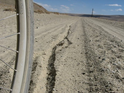
English Summary: Bad sleep because of dusty hut, noisy rats, and the altitude (4200m) waking me up gasping. Sandy roads again. Khargush military checkpoint did a complete search of my luggage (everything out and on the table). Weird feeling with Afganistan just over the river.
Ńü╗Ńü©ŃéōŃü®ń£ĀŃéīŃüŠŃüøŃéōŃü¦ŃüŚŃü¤ŃĆéÕżĢŃü╣Ńü«Õ░ÅÕ▒ŗŃü«Ńü¬ŃüŗŃü«ń®║µ░ŚŃü»ŃüÅŃüĢŃüÅŃü”ŃĆüŃüŁŃüÜŃü┐Ńü«ķ¤│ŃüīŃüåŃéŗŃüĢŃüÅŃü”ŃĆüŃüØŃüŚŃü”µ©Öķ½ś4200mŃü½ŃüéŃüŻŃü¤Ńü«Ńü¦ŃĆüÕ»ØŃéīŃü”ŃééŃüÖŃüÉŃü½ķģĖń┤ĀõĖŹĶČ│Ńü¦ŃĆüŃüŗŃéēŃüĀŃüīń®║µ░ŚŃéƵ▒éŃéüŃü”ĶĄĘŃüŹŃüĪŃéāŃüåŃĆéŃāåŃā│ŃāłŃü«õĖŁŃü¦Õ»ØŃéīŃü░ŃéłŃüŗŃüŻŃü¤Ńü¦ŃüÖŃĆé
õ╗ŖµŚźŃü«ķüōŃé鵜©µŚźŃü©ÕÉīŃüśŃéłŃüåŃü½ŃĆüńĀéŃü½Õż¦ŃüŹŃü¬ń¤│Ńü¦ŃüŚŃü¤ŃĆéŃüŗŃü¬ŃéŖĶĄ░ŃéŖŃü½ŃüÅŃüäŃü¦ŃüÖŃĆéõĮĢÕø×ŃééĶć¬Ķ╗óĶ╗ŖŃéƵŖ╝ŃüĢŃü¬ŃüæŃéīŃü░Ńü¬ŃéŖŃüŠŃüøŃéōŃü¦ŃüŚŃü¤ŃĆéŃüØŃüŚŃü”ŃāÅŃā╝Ńé░ŃéĘŃāźÕ│ĀŃüŗŃéēõĖŗŃéŖŃü¤Ńü©ŃüōŃéŹŃü½Ķ╗ŹķÜŖŃü«ŃāüŃé¦ŃāāŃé»ŃāØŃéżŃā│ŃāłŃüīŃüéŃéŖŃüŠŃüÖŃüīŃĆüŃüØŃüōŃü½ĶŹĘńē®Ńü«õĖŁĶ║½ŃéÆÕģ©ķā©Õć║ŃüĢŃüøŃéēŃéīŃü”µż£µ¤╗ŃüĢŃüøŃéēŃéīŃüŠŃüŚŃü¤ŃĆéŃüĪŃéāŃéōŃü©ŃüŚŃü¤ĶüĘÕŗÖŃü«µż£µ¤╗Ńü«ŃéłŃüåŃüĀŃüŻŃü¤Ńü«Ńü¦ŃĆüÕĢÅķĪīŃüéŃéŖŃüŠŃüøŃéōŃü¦ŃüŚŃü¤ŃĆé
Ńā»Ńé½Ńā│Ķ░ĘŃü»ŃéóŃāĢŃé¼ŃāŗŃé╣Ńé┐Ńā│Ńü½ķØóŃüÖŃéŗŃü«Ńü¦ŃĆüÕĘØŃéÆŃéÅŃü¤ŃéīŃü░ŃéóŃāĢŃé¼ŃāŗŃé╣Ńé┐Ńā│Ńü½ÕģźŃéŗŃéÅŃüæŃü¦ŃüÖŃĆéÕżēŃü¬µä¤ŃüśŃü¦ŃüÖŃā╗Ńā╗Ńā╗
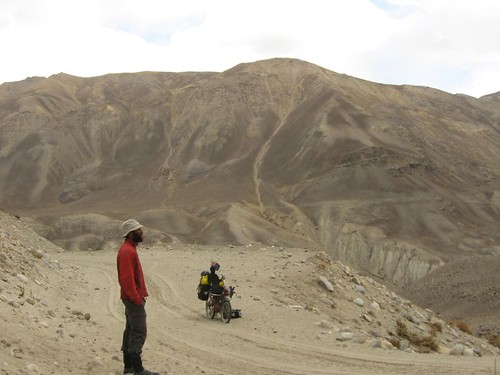
Ķ░ĘŃü»µ£ĆÕłØŃü»Õ║āŃüŗŃüŻŃü¤Ńü¦ŃüÖŃüæŃü®ŃĆüńÅŠÕ£©Ńü»ńŗŁŃüÅŃü¬ŃüŻŃü”ŃĆüķüōĶĘ»Ńü»200mŃü╗Ńü®ńÖ╗ŃüŻŃü”ŃĆüÕ▒▒Ńü«õĖŖŃü½ŃüéŃéŖŃüŠŃüÖŃĆé
The land sure looks like a moonscape. How do people inhabit such wild and inhospitable places?
We really enjoy following you on your journey. You have covered the distance amazingly quickly.
Keep out of Afghanistan eh!!??
